Moonflower Canyon Petroglyphs
Moonflower Canyon is a 0.6-mile out-and-back hike in the Behind the Rocks Wilderness Study Area just outside Moab, featuring ancient petroglyphs on impressive rock art panels, a seasonal pool, and shaded picnic areas.
While Arches and Canyonlands draw millions of visitors, Moonflower Canyon remains a local secret tucked into the Behind the Rocks Wilderness Study Area. The combination of accessible petroglyphs, a kid-friendly trail makes it a rare multi-experience gem that most tourists drive right past on their way to the national parks.
From downtown Moab, head west on Kane Creek Boulevard for approximately 5 miles. The road follows the Colorado River and transitions to unpaved after about 3 miles. Look for the signed Moonflower Canyon trailhead and campground on the left. Bathroom facilities are available at the trailhead. Free parking — no permit required for day use.
Know Before You Go
- 📵 Cell service: Expect limited or no signal. Download offline maps before you leave the trailhead.
- 🗺️ Access varies seasonally: Trail and road conditions shift with weather and snow. Verify current status with the local ranger district before you go.
- ⚠️ Conditions are not monitored live: Confirm roads, permits, weather, fire restrictions, property boundaries, and closures with the official land manager before traveling. Use the article's Sources section when available; some legacy citations are still being upgraded.
- 📅 Published: May 2026. This is the editorial publication date, not a current-condition check.
Packing Checklist
- ☐ Sturdy hiking boots or trail shoes
- ☐ 1-2L water (no refill sources)
- ☐ Trail snacks / energy bars
- ☐ Sun protection (hat, sunscreen)
- ☐ First aid kit basics
- ☐ Map or downloaded trail (no cell service expected)
- ☐ Layers — mountain weather changes fast
The Moonflower Canyon Trail punches well above its 0.6-mile weight. Tucked into the Behind the Rocks Wilderness Study Area just outside Moab, it packs ancient rock art, a seasonal swimming hole, shaded picnic tables, and a legitimate rappel into a route short enough for kids but interesting enough to keep seasoned desert rats coming back.
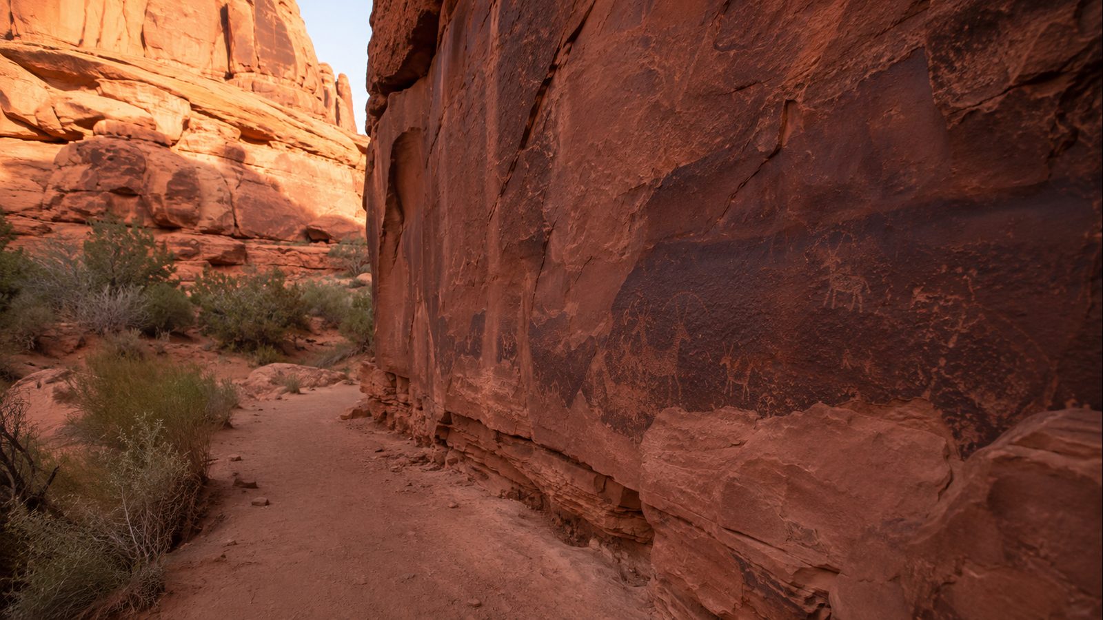
Start at the signed Moonflower Canyon trailhead off Kane Creek Boulevard. The first quarter mile follows a sandy wash past towering Wingate sandstone walls. You’ll hit the petroglyph panel about 500 feet in — a dense cluster of figures, spirals, and anthropomorphic designs left by the ancestral Puebloan people. These are among the most accessible rock art panels near Moab, and unlike some sites that have been fenced off, you can study them up close. The panel gets good midday light when the sun angles into the canyon.
Past the petroglyphs, the trail narrows and climbs gently to the rappel section. A bolted anchor sits at the top of a 30-foot sandstone face. If you didn’t bring a rope (most day hikers don’t), the views from the ledge are still worth the climb — you can see across the Colorado River corridor to the La Sal Mountains on clear days. The seasonal pool fills reliably after spring snowmelt and after summer monsoon rains, but plan on it being dry by late fall.
Verified Facts
- Trail length: 0.6 miles out-and-back with 88 feet of elevation gain (AllTrails)
- Located at coordinates 38.55426° N, 109.58699° W in Grand County, Utah (OSM Nominatim verified)
- Part of the Behind the Rocks Wilderness Study Area, managed by BLM Moab Field Office
- Features an accessible petroglyph panel with Ancestral Puebloan rock art
- Trail is dog-friendly (leash required), kid-friendly, and open year-round
- Bathroom facilities and picnic tables available at the trailhead
Actionable Takeaways
- Arrive before 9am on weekdays for solitude — weekends fill by mid-morning in spring and fall
- Bring at least 2 liters of water per person; desert conditions apply year-round
- Download offline maps before heading out — cell service is unreliable in the canyon
- Check weather before visiting: flash flood risk in narrow canyon sections after heavy rain
- Poison ivy grows thick in some sections, particularly along the wash in late spring
- Respect the petroglyphs — admire from a distance, don’t touch, and never chalk or trace them
Open Questions / Caveats
- Seasonal pool may be dry depending on recent rainfall; most reliable March–June and after monsoons
- Afternoon summer temperatures regularly exceed 100°F; hike early or late
- Kane Creek Boulevard becomes impassable after heavy rain — check road conditions at the BLM Moab Field Office