Cascade Falls — The Waterfall That Flows Out of a Cliff
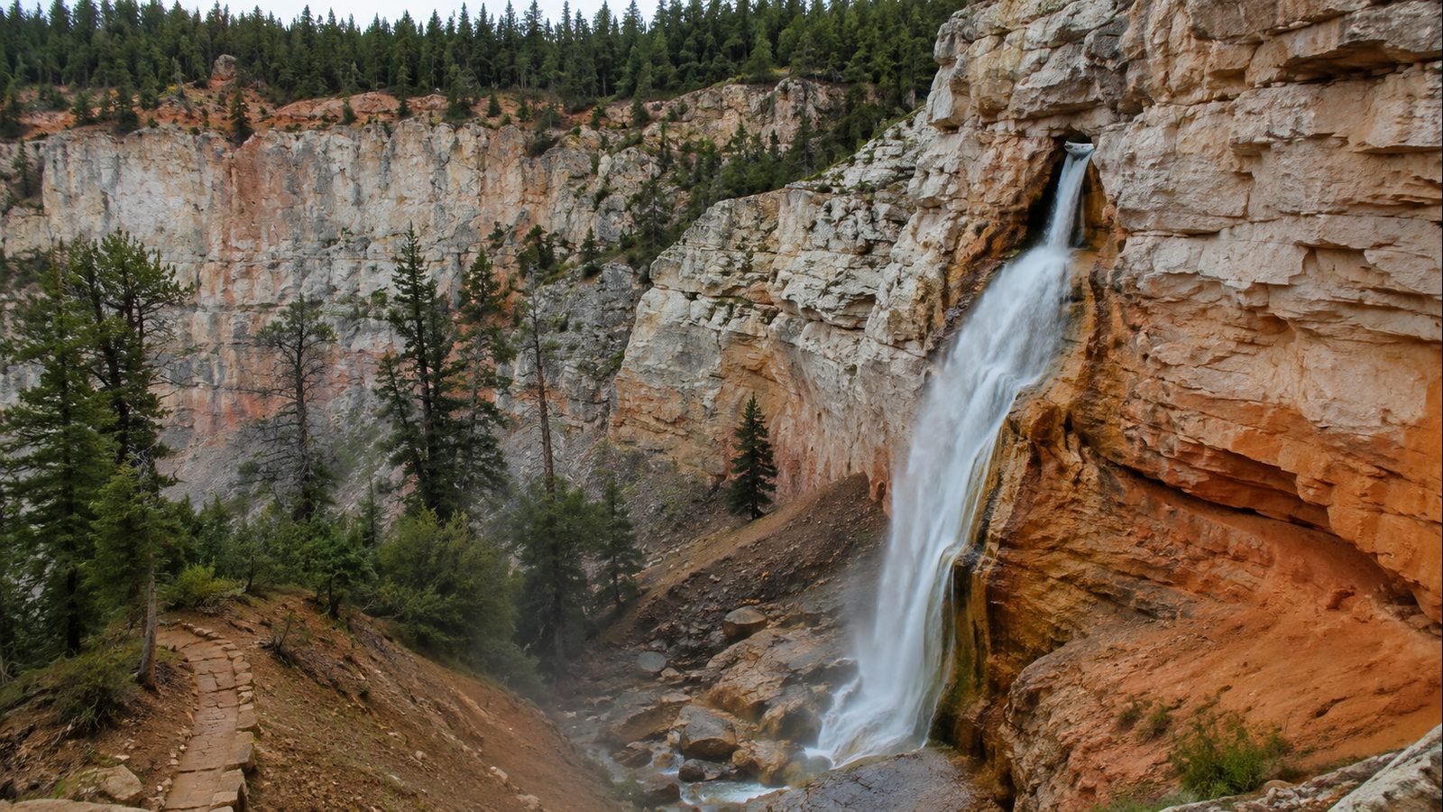
A rare geological waterfall where water emerges directly from the orange-white Pink Cliffs of the Claron Formation after traveling underground through a lava tube from Navajo Lake — creating a cascade at 8,800 feet elevation above the Virgin River headwaters.
Most visitors to Southern Utah chase the slot canyons and arches but miss this surreal waterfall tucked into Dixie National Forest. The water doesn't come from a surface river — it drains from shallow Navajo Lake through permeable limestone, then bursts from the cliff face like a secret spring. It's the kind of feature that makes geologists grin and first-timers stop in their tracks. At just 1.2 miles round trip with steps and retaining walls, it's accessible enough for families but feels worlds away from the Zion crowds.
From Cedar City, head east on UT-14 for 25 miles toward Duck Creek Village. After passing Navajo Lake, turn right onto FR053 (Navajo Lake Road). After 0.3 miles, turn left onto FR370 (Cascade Falls Road). After 1 mile, veer right onto FR054 and follow to the parking lot at the end. The Cascade Falls trailhead is on the right — do NOT take the Virgin River Rim trail, which has trailheads farther back and does not connect to the falls. Bumpy dirt road, but 2WD manageable in dry conditions.
Know Before You Go
- 📵 Cell service: Expect limited or no signal. Download offline maps before you leave the trailhead.
- 🌊 Water levels change: Seasonal flow, cold water, submerged hazards, and snowmelt can make a familiar place dangerous. Never dive or jump based on a guide description; inspect conditions in person and stay out when currents are uncertain.
- 🗺️ Access varies seasonally: Trail and road conditions shift with weather and snow. Verify current status with the local ranger district before you go.
- ⚠️ Conditions are not monitored live: Confirm roads, permits, weather, fire restrictions, property boundaries, and closures with the official land manager before traveling. Use the article's Sources section when available; some legacy citations are still being upgraded.
- 📅 Published: May 2026. This is the editorial publication date, not a current-condition check.
Packing Checklist
- ☐ Water shoes with real grip
- ☐ Quick-dry towel
- ☐ Dry bag for electronics
- ☐ Sunscreen (waterproof)
- ☐ Change of clothes
- ☐ First aid kit
- ☐ Snacks and water
Cascade Falls isn’t your typical waterfall. Most cascades are fed by a river or stream running over a cliff. This one starts underground — water from shallow Navajo Lake drains through the permeable Claron Formation limestone, travels a mile underground through an ancient lava tube, then bursts out of the orange-white Pink Cliffs at 8,800 feet. It’s less a waterfall and more a plumbing leak from a 9,000-foot lake, and that’s exactly what makes it worth the drive.
The trail itself is straightforward but never boring. You start in cool pine forest, then the trees thin out and suddenly you’re walking along the base of a massive bluff, the Pink Cliffs rising above you in bands of orange, cream, and white. The path has wooden steps and retaining walls carved into the cliffside — narrow enough to feel exciting, wide enough to feel safe. There’s a bench about halfway where you’ll probably stop whether you planned to or not, because the view across the Markagunt Plateau toward Zion National Park demands it.
When you reach the falls, the payoff depends on timing. In late spring and early summer, snowmelt feeds Navajo Lake and water pours from the cave opening in a steady curtain. By late summer or during drought years, the flow can slow to a trickle or stop entirely — which is actually fascinating in its own way. You can see the algae stains marking where water ran, the smooth-worn limestone channels, and appreciate the whole improbable geology of it. Either way, you’re standing on a viewing platform at the edge of a cliff, looking at water that just materialized out of solid rock, with Zion in the distance. Worth the bumpy drive.
Verified Facts
- Trail #32055 in Dixie National Forest, managed by Cedar City Ranger District (USDA Forest Service, last updated Aug 2025)
- Water source: Navajo Lake (9,000+ ft elevation) via underground lava tube through Claron Formation limestone
- Trail length: 1.2 miles round trip, approximately 108–150 ft elevation gain
- 1,066 reviews with 4.6/5 rating on AllTrails
- Published on Atlas Obscura June 10, 2021 — 116 check-ins, 541 want-to-go
- 50-foot waterfall height; best flow in late spring through early summer
- Pit toilets at trailhead; no water available; dogs permitted, may be off-leash in areas
- No entrance fee (Dixie National Forest); open approximately Memorial Day to Labor Day, weather permitting
- Closed to motorized vehicles, horses, and bicycles — hiking only
Actionable Takeaways
- Visit late May through early July for peak water flow from snowmelt
- Arrive before 9am on weekdays for solitude and best light on the Pink Cliffs
- Check with Duck Creek Visitor Center or Cedar City Ranger District (435-865-3700) for current conditions
- Download offline maps — cell service is spotty to nonexistent on Cedar Mountain
- Combine with Navajo Lake Loop, Cedar Breaks National Monument, or Mammoth Caves for a full day trip
- Do NOT attempt to access the falls via the Virgin River Rim Trail — separate trailhead, no connection
Open Questions / Caveats
- Water flow is entirely dependent on Navajo Lake levels; call ahead in late summer to avoid disappointment
- Trail may be inaccessible November through April due to snowpack at 8,800+ feet
- Access road (FR053/FR370/FR054) is unpaved and can be rough after storms; high clearance recommended but 2WD passable in dry conditions
- Steep drop-offs with loose rock along sections — keep children close and dogs leashed near cliff edges
- Verification note: primary sources were web-crawled (AllTrails, Waterfall Record, Zion Adventure Photog) and confirmed with official USDA Forest Service page and Atlas Obscura listing. No on-the-ground visit conducted.
Sources
- https://www.fs.usda.gov/r04/dixie/recreation/trails/cascade-falls-trail
- https://www.atlasobscura.com/places/cascade-falls-utah
- https://www.alltrails.com/trail/us/utah/cascade-falls
- https://waterfallrecord.com/2025/09/19/cascade-falls-utah/
- https://www.zionadventurephotog.com/single-post/hiking-cascade-falls-duck-creek-utah